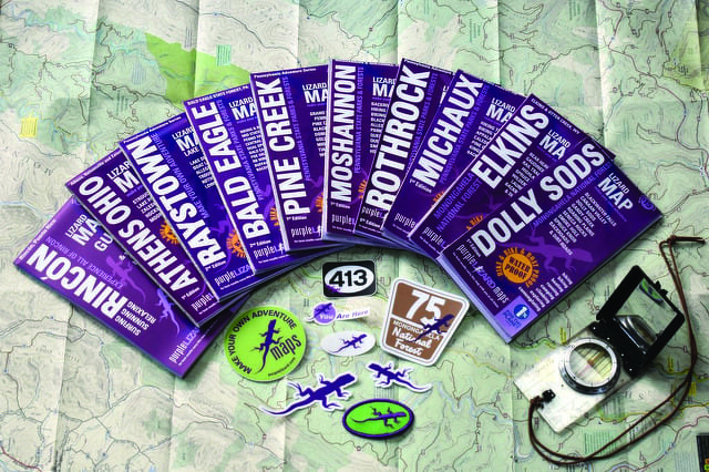
Michael Hermann, founder of Purple Lizard Maps, is an old school mapmaker in a GPS world.
While many map companies rely on satellite technology to develop their maps, Purple Lizard takes a boots-on-the-ground approach. Hermann and his colleagues spend several months immersing themselves in an area when developing a map, intimately getting to know the trails, the terrain, and the communities.
The results are extremely detailed maps designed for anyone planning any sort of outdoor adventure, from hardcore backpackers to novice hikers, bikers, and even Sunday drivers.
The maps are printed on high-quality, waterproof paper, easily identifiable by their purple cover. Hermann has resisted the idea of making Purple Lizard Maps available in an app, preferring instead to encourage people to break free from technology for a while.
“I think the underlying goal of Purple Lizard is to get people outside and help them unplug from the constant contact world we’ve created,” he says.
“What makes our maps unique is the content is so curated. Things are added that aren’t on other maps; things are tailored to what we think people want to find, the experience they want to have. … So many maps are bad – they’re hard to read, they’re inaccurate, and they’re not really all that helpful – so when people open up a Purple Lizard map they should be pleasantly surprised. It’s a really engaging piece. It’s like getting sucked into a good book.”
One of the hallmarks of a Purple Lizard map is the use of the purple lizard icons to denote places of interest.
“Sometimes you just walk through the forest and you find a really special place, like a pocket of old growth or a scenic overlook, but it doesn’t have a name on any of the other maps. The lizard is a way to give people a hint that something cool is there,” Hermann says. “Now we have people that try to find every lizard on a map.”
Artistic and creative as a child, Hermann graduated from the State College Area High School Delta program before going on to manage The Bicycle Shop on West College Avenue after a year at Penn State. He became deeply involved in the local outdoors scene, a passion that eventually led him back to Penn State to study geography and cartography, a perfect outlet for his artistic side as well as his outdoor explorer side, he says.
Upon receiving his degree in 1995, he took a job at National Geographic Maps in Colorado before going out on his own as an independent cartographer and returning to the area to establish Purple Lizard Maps. He has gone on to win design awards in his field.
“I think in the era of Google maps and GPS, people forget there’s still a craft and an art of mapmaking,” he says. “We really work on the aesthetics, and making a map that’s beautiful enough for people to want to hang it up as a piece of art, but also that’s a pleasure to use.”
With the addition of an Ohiopyle/Laurel Highlands map this month, there are now 11 Purple Lizard maps in circulation, covering parts of Pennsylvania, West Virginia, Ohio and Puerto Rico. This year, the company will release the seventh edition of the map that started it all, the Rothrock map, first published in 1997. The maps are distributed online at purplelizard.com and at 120 different retailers, mainly in nontraditional locations such as coffee shops, microbreweries, outdoors stores, and bicycle shops.
“We’ve actually turned down chain stores and bigger forms of distribution, because we don’t really want to be associated with that market. We much prefer to support businesses that mirror our values and outlook,” Hermann says.
This sort of “anti-corporate” outlook is also reflected by their membership in “1% for the Planet.” One percent of their gross income is donated to participating environmental charities of their choice.
“In every place that we map, we identify local nonprofits that we feel are a good match for the environmental and outdoor community,” Hermann says. “Locally, our biggest partners are Penns Valley Conservation Association and ClearWater Conservancy.”
In fact, they are currently working with ClearWater Conservancy to reissue an updated map of the Scotia Trail area.
“That was a map that we might not have taken on just as part of our product line because it’s really hyperlocal, but it really showcases ClearWater’s efforts of conservation in that area,” he explains.
Also on the horizon for the company is a map of the Loyalsock State Forest area near Williamsport, and a map of Cook Forest State Park in Clarion County.
While Hermann seems to fall in love with every area he maps, he says one of his favorite places is still a spot that appears on that original Rothrock map.
“When people ask me where I like to go, the Alan Seeger Natural Area is always high on my list,” he says. “That’s a gem, and a lot of people don’t know that it’s there.”
Hermann says local and state officials sometimes ask Purple Lizard to develop a map of their area, but he prefers to remain independent to maintain creative control. But still, he says, it’s gratifying to see the positive effect he believes the maps can have on local communities.
“We’ve developed such a loyal following. Every time Purple Lizard publishes a new map, people put it on their list, like, ‘We’re going there; we’re going to do a weekend in that place because Purple Lizard just gave us all the tools to go explore,’ he says. “In that way, I think we’re sort of driving tourism.”
Karen Walker is a freelance writer in State College.


